


GR-34-_-montstmichel-stbrieuc (1)

daniel_2w
User
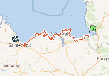

Length
246 km

Max alt
99 m

Uphill gradient
3715 m
Km-Effort
296 km

Min alt
-1 m

Downhill gradient
3624 m
Boucle
No
Creation date :
2024-03-14 20:43:32.416
Updated on :
2024-03-28 16:57:27.963
0m
Difficulty : Very easy

FREE GPS app for hiking
 SityTrail
IGN / Geographical institutes
SityTrail Plus
The world is yours!
About
Trail Nordic walking of 246 km to be discovered at Normandy, Manche, Le Mont-Saint-Michel. This trail is proposed by daniel_2w.
Positioning
Country:
France
Region :
Normandy
Department/Province :
Manche
Municipality :
Le Mont-Saint-Michel
Location:
Unknown
Start:(Dec)
Start:(UTM)
609682 ; 5387959 (30U) N.
Comments